Projects
| [ home ] [ projects ] [ people ] [ publications ] | |
|
|
Projects |
|
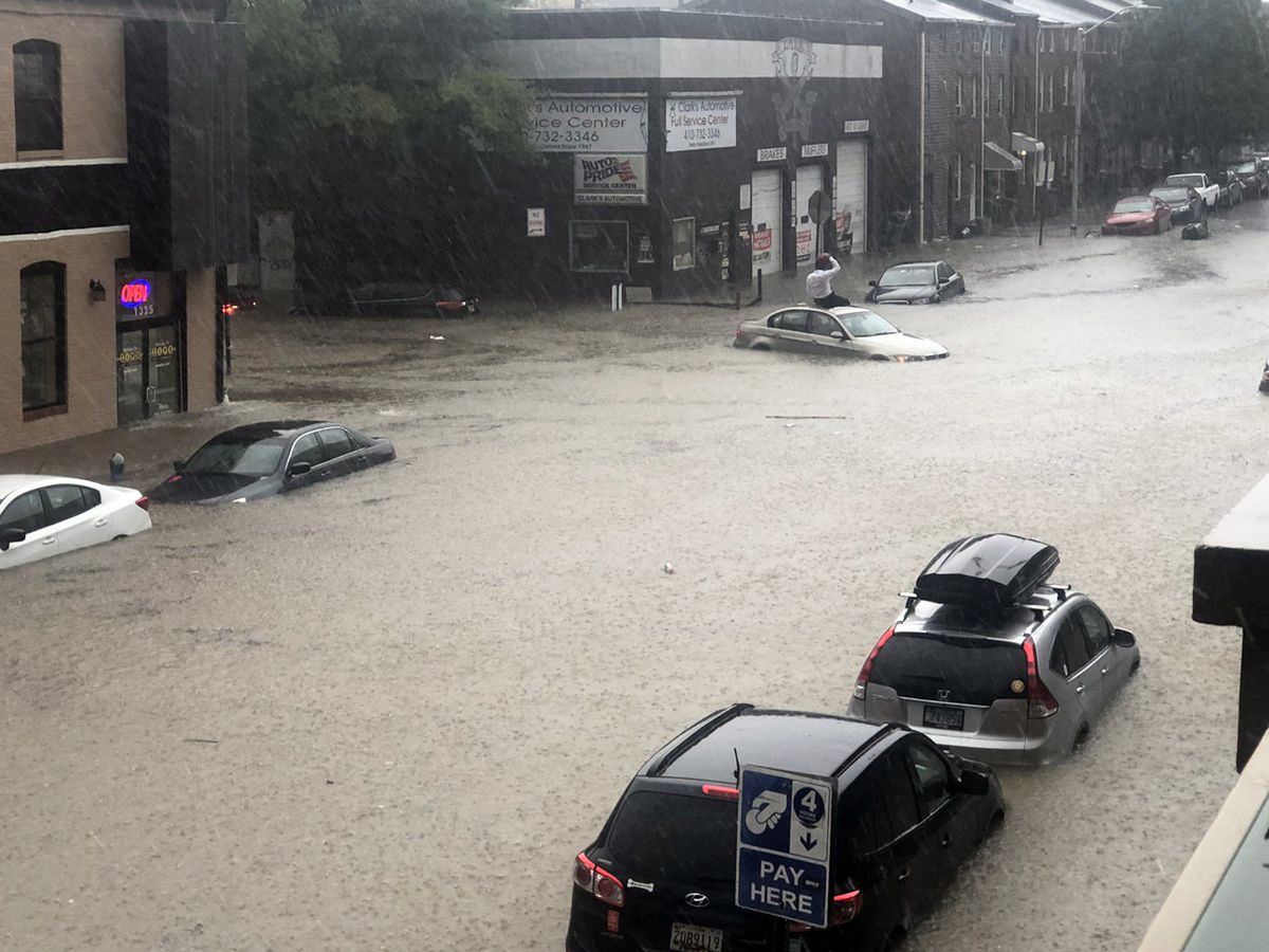
| Equity-oriented urban climate adaptation | |
The Hydroclimate Research group is engaged in multiple transdisciplinary projects to advance equity-oriented climate resilience strategies in Baltimore. This work occurs in close collaboration with the City of Baltimore, neighborhood partners, and urban environment and development organizations. Specific projects include the Baltimore Social Environmental Collaborative Integrated Field Laboratory, for which Dr. Zaitchik is Lead PI, a NOAA-sponsored project on urban heat island mapping and participatory multi-objective mitigation analysis, and a collaboration with Morgan State on the RAND Corporation-led MARISA initiative for climate resilience in the mid-Atlantic region. In all of this work, we combine physically-based observation and modeling with stakeholder-driven multicriteria analysis of adaptation options. Research products include interactive planning tools that allow decision makers to evaluate the impacts of a range of adaptation strategies with respect to their own defined equity indicators. |
 |
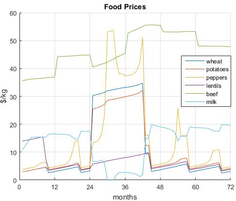
Studies of the Food-Energy-Water Nexus in sub-Saharan Africa |
|
|
Africa is undergoing an energy revolution. Centralized electricity production and grid connections are multiplying electricity access for cities and industry in emerging economies across the globe, while distributed renewable technologies offer opportunities for communities beyond the grid. These changes are transforming societies, and they have diverse impacts on food systems, and ultimately food security, from household to international scale. At the same time, climate change has the potential to impose both local and global hydrological shocks that affect food and energy systems at multiple levels. To understand and predict these dynamics, we are consturcting a systems-based multiscale modeling framework that captures local to national scale food, energy, and water dynamics in a changing climate. The framework is being implemented for Ethiopia and Mali, two rapidly developing but highly climate vulnerable countries that serve as test cases for a more generalizable analysis system. This work is a multi-institution effort led by JHU and supported by the NSF. We also lead a complementary Food-Energy-Water project that applies socio-ecological systems analysis in the Blue Nile basin and is supported by the Belmont Forum. |
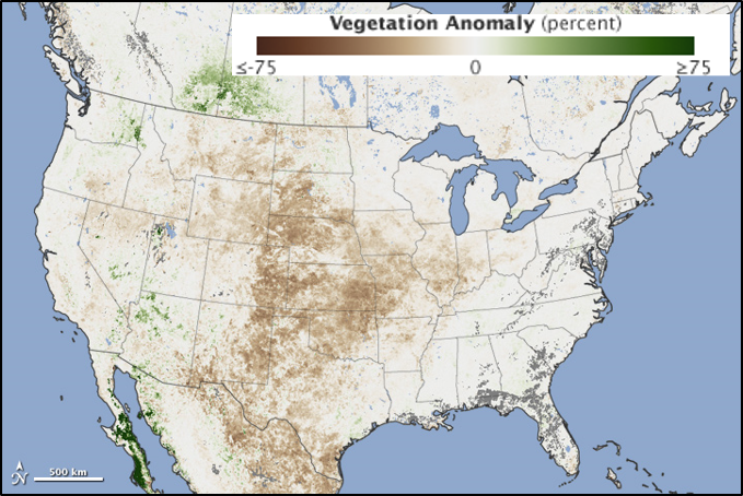
| Flash droughts in the United States: understanding process to inform prediction | |
Drought is often thought of as a creeping disaster; one that emerges slowly over time. In contrast, "flash droughts" intensify dramatically in just a few weeks. These flash droughts are poorly represented in current forecast systems, hindering drought preparedness. In collaborations between JHU, the USDA, NASA Goddard Space Flight Center, the University of Wisconsin, and UC-Berkeley, supported by the NSF and NASA, we study the critical role that plants play in the development of a flash drought. Our studies leverage new satellite technologies, machine learning, and dynamical atmospheric modeling to elucidate the role that vegetation plays in the development of flash droughts in different ecological and climatic contexts. The findings are then applied to prediction systems designed to anticipate flash droughts weeks to months in advance. |
 |
Environmental predictors of enteric disease risk |
|
|
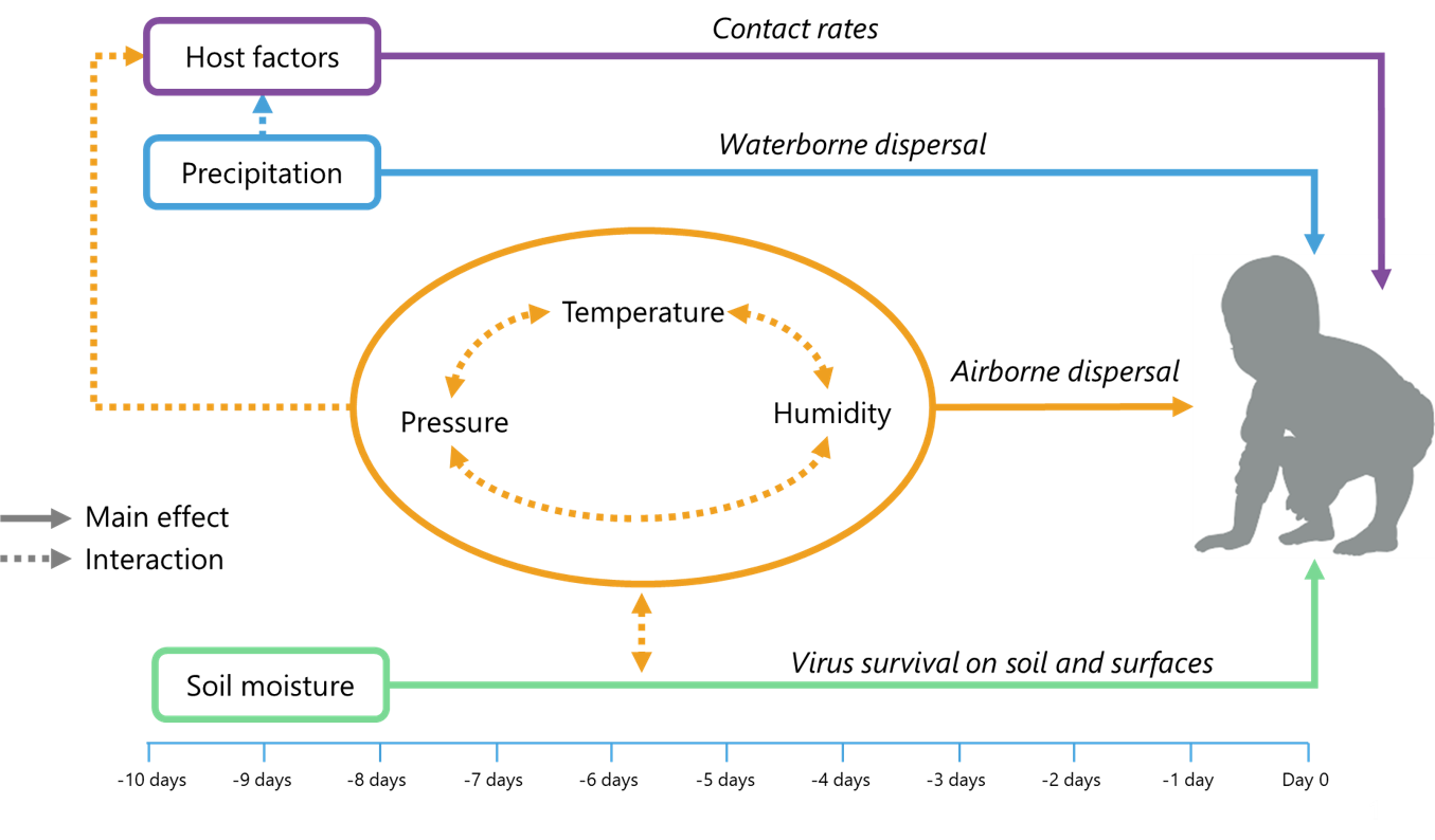
Diarrhea associated with enteric infectious diseases (EID) is a leading cause of mortality and morbidity in young children in many countries. EID prediction and prediction-informed prevention activities have traditionally been hindered by a lack of detailed disease surveillance and reporting data; even in places where records of diarrheal illness are kept, information on which type of bacteria, virus, or protozoa was responsible is often unreliable or absent. Leveraging recent international studies designed to track cohorts of children at risk of EID, we are working to merge diverse Earth Observations with detailed disease records to generate descriptive and predictive models of environmentally-mediated EID risk. The work is being pursued with NASA funding under the Group on Earth Observation (GEO) Health applications initiative. |
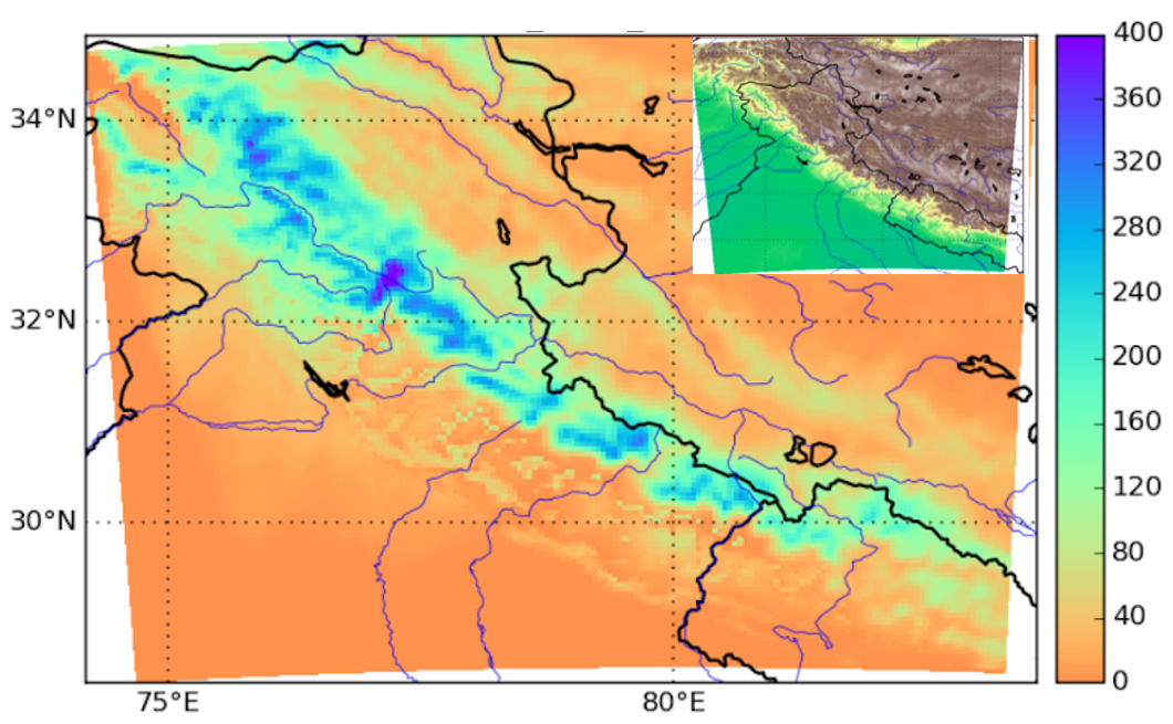
| Deep learning for downscaled climate projections in High Mountain Asia | |
High Mountain Asia is experiencing among the fastest rates of climate change in the world. In support of the multidisciplinary efforts of NASA's High Mountain Asia Science Team, we are generating a multimethod suite of high resolution future climate projections for High Mountain Asia. These projections are derived from global simulations produced for the 6th Coupled Model Intercomparison Project (CMIP6) and are downscaled to 5km resolution using deep learning methods, linearized dynamically-based models, and more traditional statistical learning techniques. We collaborate with researchers from NASA and NCAR on the project. |
 |
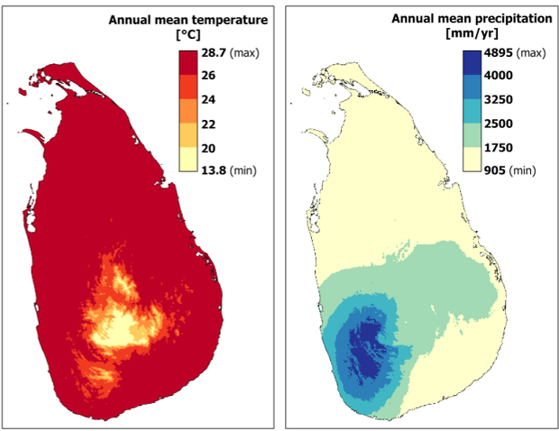
| Dengue Early Warning in Sri Lanka | |
|
Dengue is known to be a climate-sensitive disease, but knowledge of these sensitivities has yet to translate into operational environmentally-informed early warning systems. In collaboration with JHU colleages in the Whiting School of Engineering and the Bloomberg School of Public Health, and working closely with partners in Sri Lanka, we are integrating satellite-derived environmental information with relevant social and health information to generate process-informed dengue predictions that are relevant to operational decision needs. This work is supported by a JHU Discovery Award |
| Improved seasonal hydrological forecasts in South Asia | |
Hydrological variability presents significant challenges to human safety, agricultural production, and water resource management across South Asia. Producing reliable and actoinable hydrological forecasts for the region is a grand challenge that requires advances in models, observation, and the design and communication of forecast-based decision support products. In a series of collaborative projects funded by NASA SERVIR and the Skoll Global Threats Fund we have developed a land data assimilation system for hydrological monitoring and analysis across South Asia. We are currently extending this system to provide ensemble seasonal hydrological forecasts, with a focus on the Hindu Kush-Himalaya region. This work is being performed in close partnership with the International Center for Integrated Mountain Development (ICIMOD) and the SERVIR HKH hub, and with research partners at NASA Goddard Space Flight Center and the University of Wisconsin-Madison. |
 |
The African Cholera Risk Early Warning System (ACREWS) |
|
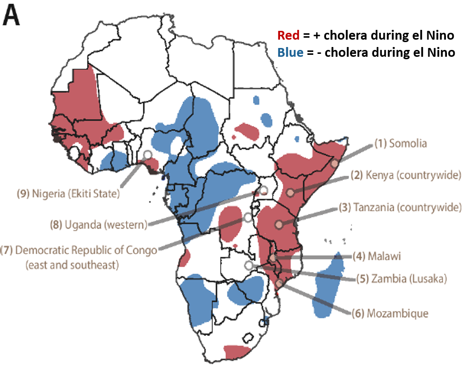 |
Cholera, a waterborne disease transmitted by the bacteria Vibrio cholerae, infects millions around the world every year, with the greatest burden in Africa. Cholera has long been described as a climate-sensitive disease, but in Africa this sensitivity is complicated and context-dependent. In some places excess precipitation can trigger an outbreak, while in others cholera tends to spike during drought. Building on our initial findings on El Nino Southern Oscillation influence on cholera distribution in Africa, we are now working with NASA support to collaborate with the WHO's Global Task Force on Cholera Control to create an operational African Cholera Risk Early Warning System that can inform deployment of resources for cholera control. To do this we leverage unprecedented health data on cholera incidence in countries across Africa and Earth Observations in the form of satellite retrievals, a land data assimilation system, and seasonal meteorological forecasts. |
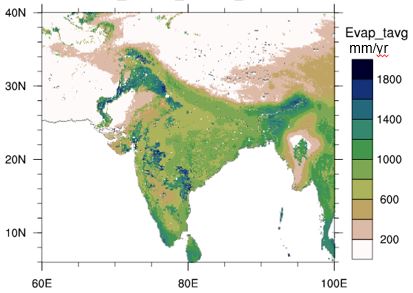
Hydrometeorological information for the countries of the Nile basin |
|
 |
We have developed dvanced remote sensing and land surface models for Decision Support on hydrologic variability, climate change, and land management in countries of the Nile basin. Satellite remote sensing provides high frequency, spatially complete information on landscape processes and characteristics. This information is integrated with physically-based land surface models to provide best-available estimates of hydrological states and fluxes, which in turn provide actionable information related to flood protection, agricultural planning, drought monitoring, and climate change adaptation. Current project activities include irrigation mapping, satellite and model based evapotranspiration estimates, and land surface modeling of hydrological states and fluxes. |
| A Malaria Risk Monitoring and Early Warning System for the Western Amazon | |
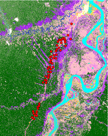
Almost 90% of malaria in the Western Hemisphere is located in the Amazon, and 50% of the total malaria burden in the Americas is located in 44 municipalities of Peru, Brazil, and Venezuela,where dynamic land use activities place people and Anopheles mosquitoes in close proximity, leading to elevated risk of malaria transmission. The temporal and spatial factors governing risk of exposure, however, are poorly characterized, which limits the efficacy of control strategies and the distribution of health resources. There is a need for spatially explicit models that monitor and predict transmission risk on the basis of joint landscape and human behavioral factors. Land Data Assimilation Systems (LDAS) offer a powerful opportunity for informing malaria risk models with spatially explicit, time-varying estimates of hydrological conditions. In NASA and NIH funded projects led by Dr. William Pan of Duke University we apply LDAS and S2S forecast to support a Malaria Early Warning System for countries of the western Amazon. |
 |
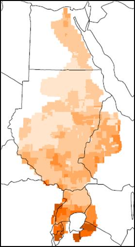
| Climate Change Resilience in the Ethiopian Highlands | |
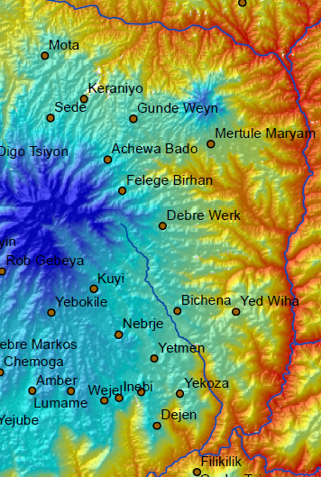 |
Coupled processes of low investment capacity and land degradation currently drive a cycle of depressed agricultural yields and persistent poverty through much of the Ethiopian Highlands, including the Blue Nile (Abay River) headwaters (BNH) region. There is reason for concern that conditions in the BNH will deteriorate in coming decades, given a changing climate that could well bring more frequent drought and more intense precipitation events to the region. This is expected to take place in tandem with continued population growth and the potential for external land use pressures. However, the same coupling of natural and human systems that currently reinforces poverty in this region also offers opportunity. Working closely with collaborators at Addis Ababa University, along with an interdisciplinary research team of social and physical scientists, development practitioners, and local experts, we are identifying methods for applying climate and hydrological analysis in support demonstrated climate resilience building activities in the BNH. |
| Explaining the Urban Heat Island | |
Working with partners at the Maryland Institute College of Art (MICA), the City of Baltimore Office of Sustainability, and numerous schools and community groups in Baltimore City and the surrounding area, we are implementing a high density, low cost urban heat monitoring network. This network is being used in combination with satellite data to characterize the city's heat island and its sensitivity to climate variability and land cover. These analyses then feed into high resolution regional climate modeling efforts that are designed to simulate the urban heat island and to inform mitigation strategies. |
 |
| Heat Waves in the Southeast: Patterns, Trends, and Health Impacts | |
In collaboration with researchers at Virginia Tech and the University of Alabama at Birmingham, we are investigating the health impacts of extreme heat events in the Southeast United States. Making use of a combination of remote sensing techniques and climate reanalyses, we are examining how various forms of extreme heat events impact urban and rural populations, identifying heat wave diagnostics that most effectively capture these health impacts, and projecting evolving patterns of heat vulnerability on the basis of climate change projections and the vulnerability profiles of different communities. |
|
| Satellite Monitoring of Chesapeake Bay | |
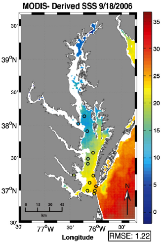 |
Estuaries like the Chesapeake Bay are dynamic environments, subject to variable currents and mixing processes that produce high temporal and spatial variability in water properties relevant to hydrodynamics, water quality, and ecology. Estuarine and coastal environments are also increasingly vulnerable to adverse environmental, biological, and societal change under pressures of human population growth, sea level rise, land degradation, and climate change. The highly variable and evolving nature of these environments makes them notoriously difficult to survey and monitor. As conditions continue to change in poorly characterized and unpredicted ways, there is a vital need for more advanced and spatially complete monitoring networks. Working with collaborators at the JHU Applied Physics Lab, the University of Maryland, NOAA, NASA, the University of Rochester, and other institutions, we are developing satellite-derived estimates of surface salinity in Chesapeake Bay in order to inform development of hydrodynamic models and to improve the accuracy and completeness of operational water quality and pathogen models. |
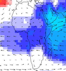
Dynamics of East African Precipitation |
|
The hydroclimate research group participates in a multidisciplinary Earth & Planetary Science Department initiative on African climates. Under this initiative, we are currently employing a suite of climate modeling, remote sensing, and geochemical techniques to improve understanding of precipitation dynamics in the East African highlands. This study will advance understanding of atmospheric processes influencing rainfall in the region. It will also contribute to efforts to interpret records of past climate and to evaluation of global climate models used to project future preciptiation patterns under climate change. Other work under the African climates initiative includes objective regionalization of African climate zones, improved seasonal preciptiation predictions, and satellite-based drought monitoring. |
|
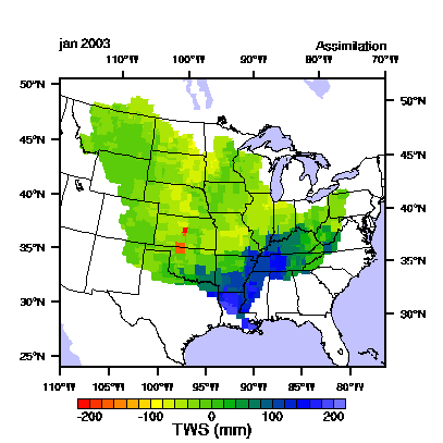
| The GRACE Data Assimilation System | |
NASA's Gravity Recovery and Climate Experiment (GRACE) mission has the potential to be extremely valuable for water resources applications and global water cycle research. What makes GRACE unique among Earth Science satellite systems is that it is able to monitor variations in water stored in all forms, from snow and surface water to soil moisture to groundwater in the deepest aquifers. However, the space and time resolutions of GRACE observations are coarse. GRACE typically resolves water storage changes over regions on the order of 100,000 km2 on a monthly basis, while city-scale, daily observations would be more useful for water management, agriculture, and weather prediction. The GRACE Data Assimilation System integrates GRACE observations into an advanced land surface model, yielding new estimates of water and energy fluxes and storages that are informed by GRACE and that can be produced at high model resolution. |
 |
| Coupled regional climate modeling | |
|
Our group works on both the development and application of coupled climate models in order to improve our understanding of regional climate variability. Regional drought processes are a subject of particular interest. |